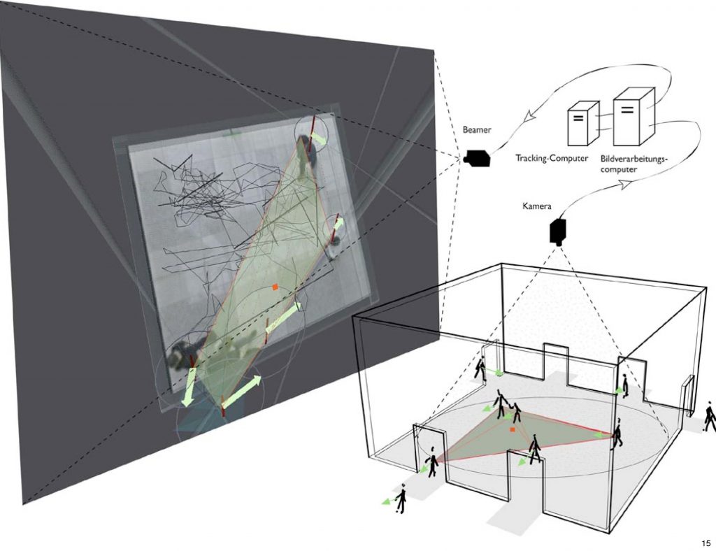
Die Installation trace pattern ist erste Station von inoutSite, das Raumgeometrie von Bewegung von Menschen auf öffentlichen Plätzen ableitet. Eine Kamera nimmt die Situation in einer offenen Fläche wahr, die Personen werden anhand dieser Bilder verfolgt (hier nur 2), ihre Bewegungsspur berechnet und miteinander verglichen. Ist der Ort, wo eine Person hingeht oder herkommt identisch mit dem Ort, wo eine andere Person sich hin orientiert/den sie verläßt, dann wird Abstand und Winkel zwischen den Bewegungsbahnen berechnet und überprüft, ob diese in eine Raumgeometrie passen, welche als eine Erweiterung der Proportionenlehre (basierend auf dem goldenen Schnitt) gesehen werden kann. Ist dies der Fall, werden an die Aufenthaltsorte der Personen geometrische Muster angelagert, die Parkettierung von regulären Polygonen sind. Die Muster bilden eine Art Netzwerk zwischen den beiden Personen. Bewegen sie sich fort, so wird das Muster nicht weiter gezeigt. Verweilen sie, bauen sich verschiedene Varianten der Polygonanlagerungen auf und ab. Gleichzeitig sind Akkorde hörbar, die aus den Seitenlängen der Polygone abgeleitet sind. Gibt es eine Entsprechung zwischen Klang und Muster?
Gleich der Funktionsweise eines Seiteninstruments wird die Geometrie (die Seitenlänge der Polygone) in Klänge umgesetzt.
Während diese Muster angezeigt werden, kann der Betrachter sich selbst (repräsentiert als eine Kugel) innerhalb des Musternetzes betrachten. Er kann überprüfen, ob diese Muster etwas mit seinem Raumempfinden zu tun haben oder nicht. Er kann spielerisch erproben, sich so zu verhalten, daß zwischen ihm und einem Nachbar Muster entstehen. und die Regeln des virtuellen auf den realen Raum übertragen.
Sowie hexagonale Muster in der Geographie zur Beschreibung der “Zentralität der Orte” (W. Christaller, Die zentralen Orte in Süddeutschland”, Jena 1933), also der wirtschaftlichen Vernetzung von Siedlungen untereinander, herangezogen wurden, möchte ich mit wesentlich komplexeren Netzen Möglichkeiten anbieten, Raumelemente ebenfalls vernetz- und planbar, aber auch adaptionsfähiger zu machen. Die interaktive Installation ermöglicht, Nähe und Distanzwunsch zu Personen überprüfbar zu machen. Im weiteren Verlauf wird die Perspektive umkippen aus der Beobachtersituation “Froschperspektive” in die Position des Betrachteten, der mit seinen Bewegungen (virtuellen) Raum generiert.
“… Der größte Teil dessen, woraus unsere Körper und Gehirne bestehen, wird schließlich fortwährend ersetzt, und nur die Strukturen oder Muster bleiben erhalten. Außerdem scheint die Materie selbst lediglich vorübergehend zu exisiteren, weil sie von einer Form in eine andere umgewandelt werden kann. … Die Materie selbst ist also nebulös und flüchtig, und es ist gar nicht unvernünftig anzunehmen, daß die Beständigkeit des “Selbst” mehr mit der Erhaltung von Strukturen zu tun haben könnte als mit der Erhaltung von vorhandenen materiellen Teilchen.”
Roger Penrose: “Schatten des Geistes”, Heidelberg 1995
Bei den Instllationen des “inoutsite”-Projektes wird die Häufigkeit der Passagen von Personen auf öffentlichen Plätzen untersucht und in virtuelle Bilder und Klänge umgesetzt.
Das sich ergebende Bild kann gesehen werden als erste Annäherung an eine virtuelle Architektur. Inoutsite I und II zeigen die Statistik des Raumes: Pfeile (grün) indizieren die Gehrichtung, Linien (hier Röhren) sind die Spuren der einzelnen Personen. Die Höhe des Netzes, das wie eine 3D Chart und luftiges Dach über dem Platz schwebt, zeigt die Gesamtverteilung der Spuren auf dem Platz. Umso niedriger das Netz, umso seltener war dort eine Person.
Das Verfahren, zwei Bilder als Kreuz zu einer behelfsmäßigen Rekonstruktion einer 3-D Ansicht zusammenzufügen, wird hier Installationsvorgabe. Es soll ermöglichen, daß der Betrachter die Gehspuren wirklich als räumliches Event erlebt und nicht nur als eine distanzierte Abbildung auf einem Monitor. Damit wird auf das Fernziel des Projektes verwiesen, nämlich die Entwicklung von Architektur.
Entwurf für eine interaktive Installation auf einem öffentlichen Platz
Ein öffentlicher Platz soll Szenario eines Interaktionsraumes werden, z.B als ein Cafe oder Ausstellungsgelände, das aus modularen, beweglichen, sich selbst organisierenden Elementen besteht. Es soll als lernfähiges mobiles Mobiliar das Wesen von Orten im öffentlichen Raum und ihre Nutzung durch die Besucher deutlich machen. Die Organisation des Nutz- und Freiraumes, z.B. von Sitzgruppen, Raumteilern und Tischen soll sich an der aktuellen Raumnutzung orinetieren und durch die Inanspruchnahme der Benutzer lernen, sich entsprechend ihrer Vorlieben zu verhalten. Als sturkturelle Maßnahme werden Mediale Elementedes Raumes an den Grenzen von Ruhe- oder Durchgangsbereichen plaziert.
Sessel und Tische bilden Gruppierungen je nachdem wo und wieviel Besucher-Andrang vorhanden ist: zu Mehreren oder Einzeln, in Randbereichen oder im Zentrum. Medienmöbel bilden Kommunikationsumgebungen je nach Benutzung des Raumes. Dadurch bildet sich eine Architektur, die Abbild sozialer Prozesse ist.
Die Raumanordnung ergibt sich aus dem Bewegungsverhalten der Benutzer. Um den Besuchern eine bewußte Einflußnahme auf die Gestalt und die Entwicklung des Cafes zu ermöglichen, soll es online und onsite (Palmsized-Computer) möglich sein, das Geschehen vor Ort zu beeinflussen und sich über die aktuellen Möglichkeiten, welche von der Umgebung angeboten wird, zu informieren (Orientierung, Navigation).
The ‘Zeitraum’ Installation is the most recent “inoutside”-installation in the series of video tracking installations for public spaces.
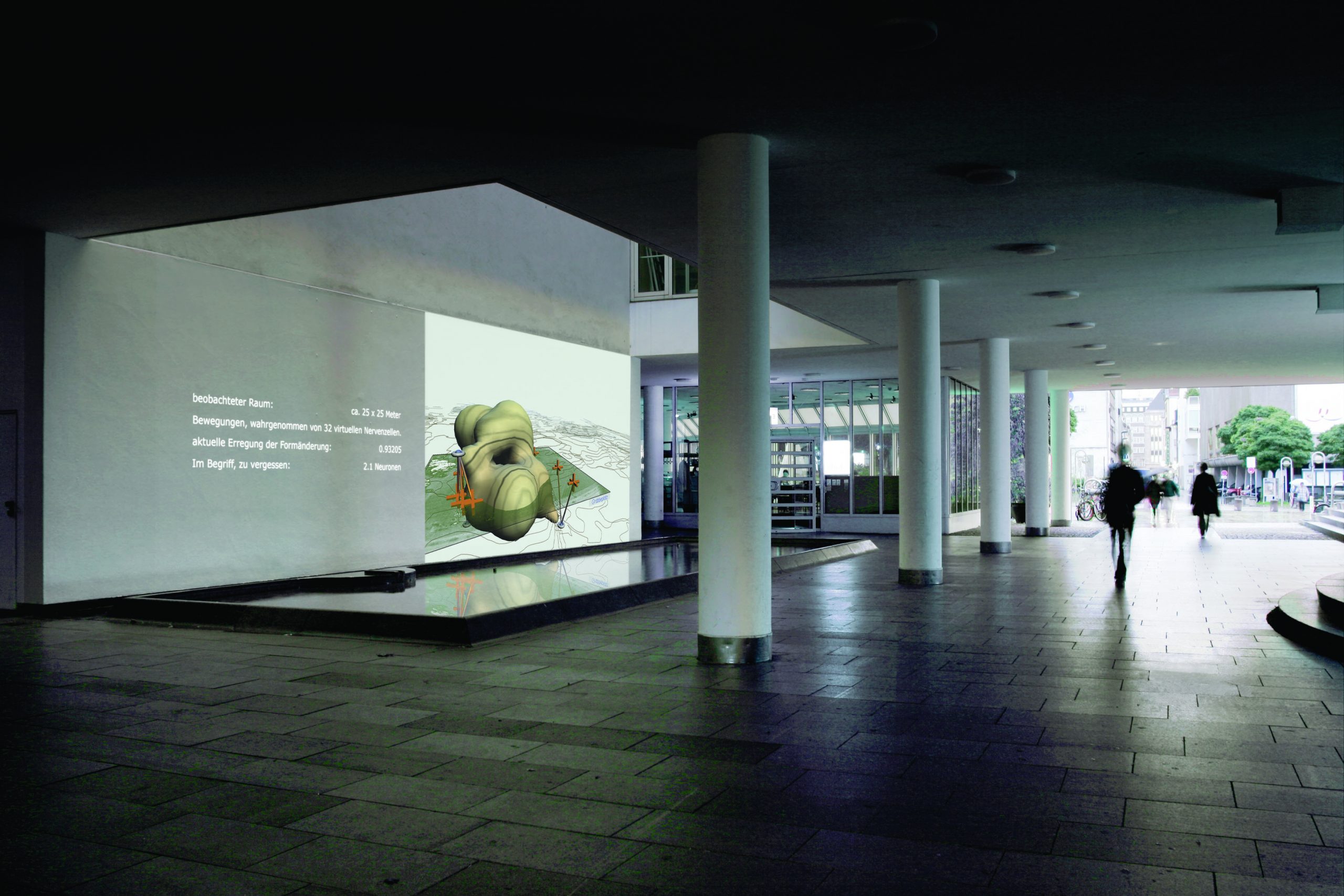
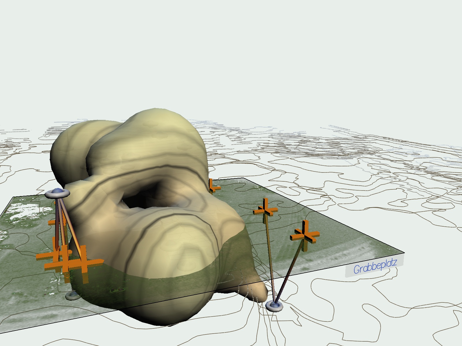
One perceives a virtual sculpture space-envelope come into being and vanish. This everchanging sculpture is controlled by the occurrences on Grabbeplatz. Like a naturally grown architecture this form is embedded into the contours of the immediate environment of the current location of the viewer. The positions of the people on Grabbeplatz as well as the position of the viewer of the picture are marked with red crosses. Connecting lines point from marked people approximately onto the place of the space-envelope where the people influence the generated form. The installation is made up of nightly projections onto the fountain wall in the passageway of K20. On the roof of the art collection two infrared emitters and an infrared camera are installed. The emitters make up for the missing daylight, so that the camera may pick up the motions on the site. The regular light is an important prerequisite to be able to deduct the motions of the people. This is done by a video tracking program. It is determined where on the site movement takes place by comparing the current video image with a previously taken image of the empty site. The results are then sorted by “blobs”. “Blob” signifies a “Binary Large Object” and denotes a field of non-structured coordinates which moves equably. These animated data-fields are passed on to a graphic- and sound program that calculates the virtual sculpture from the abstracted traces. In this the motion traces are interpreted. As in earlier installations such as “memory space” (2002), “trace pattern II” (1998) or “inoutside I” (1998) and “inoutside II” (1999), the supplied video image is visible on the basis of a video texture so that the people who see this image may recognize themselves in the virtual image. So it becomes clear how the virtual forms, the clouds and arrows are calculated.
The installation deals with architectural and city-planning concepts. A new, different design technique should be attempted, that is aimed at observing the behaviour of people towards architecture. The goal is to depict the city or architecture as a dynamic organism. To show city and people as something collective, something in constant transformation, is what the installation wishes to convey. top
interface/surveillance
The system, the way we used it in the six “inoutside”-installations does not allow for humans to be apprehended in their individuality. It is not about recognizing what makes up each person per surveillance system (for this we humans are still better at than machines), but about perceiving the quality specific to the site and to test it on humans and human behaviour. It’s about the cognition of behavioural patterns, but not about a description of the individual. Moreover the site should be individualized to ascertain its character. top
data processing
With the recording of traces it is so, that the means of computation that is being done in the installation aims to characterise the site, whereby the collecting of the different individual traces becomes essential. The early installations such as “trace pattern II” (1998) are obviously geared towards the interaction amongst the people. The behaviour of the people is recorded, amplified and interpreted: Do they walk close to one another? Are they walking away from each other? Are there “Tracks” – several people walking in step? These observations become part of the interpretation. In the current installation in K20 the space is represented in form of one or multiple bodies. These bodies have entrances and exits, openings and closures, they are being bundled from small units or melt into a large whole or divide. They swell or make holes that enlarge until the bodies dissolve. All these spatial elements are determined by the behaviour of the people. We also map the traces of the visitors of the site according to their different walking-pace and according to their frequency of presence on site onto a mathematical shape-the Isosurface that changes according to behaviour.
The neural network, here the Kohonen map learns through self-organization. This is a method of learning based on the neighbourhood relations of neurons amongst each other. A network is constructed which depicts that which is on the site. Beyond this the classical SOM is modified in order to solve the problem, which is created when the monitored space is a limited area. For at the edge different conditions for calculation apply than in the middle, because the condition of a site is also rooted in its neighbourhood. In the simulation of physical processes one defines the monitored area simply as a torus or a sphere, whereby that, which for example disappears on the right image border, re-appears on the left. This doesn’t make sense for a real site however, which is why we modified the procedure: in the regions with too great an impulse density we let the neurons descend into a second plane that disperses the neurons onto the nearest places that lack neurons. Through this we created a compact cyclical energy evaluation that prevents that only a cluster of the SOM would stay in the middle of the space (see graphics). This would be nothing other than too high of an information density that could provide no information whatsoever (almost a black “data hole”). For me as an artist the application of neural networks in very exciting, because they demand of me that I restrain my artistic and visual desires for the sake of processes which happen with the help of this camera eye – in reality not by the camera but by the people that are the focus of the camera, so by the image of the site. Since the computer-internal data processing apparatus imitates the human perception apparatus, it demands of me that I be concerned about the limits of perception and the possibilities and impossibilities of projection of knowledge.
the isosurface
Isosurface in action
As already mentioned the Grabbeplatz is being reproduced in a virtual image through video texture. It marks the area recorded by the tracking-program, over which the calculations generate an abstract space. The nodes of the SOM form trajectories in this space, nurtured by impulses that refer to speed, direction and length of stay of the passers-by. So the level tracking plane is expanded by another dimension. To visualize the relationships of the nodes not only as points in the room but also in relation to one another, we let an imagined potential energy function reign in the surrounding of every which node. This function is represented as a surface in space. This follows the path of every node and adapts its shape to its current role in the SOM. Such surfaces are called Isosurfaces. They are used to represent the homogeneity of energy states (here: potential energy states) within a continuum. All points of this surface represent an equivocal condition. The potential energy functions- one for each node- overlap or avoid another, amplify or cancel each other out. This event visualizes surfaces which comparable to soapy skin melt into or drip off each other or lose themselves in infinitely minute units. In the arithmetic sum of all the individual potentials lies the key to these surfaces. All points in the room are determined whose potential energy function reach a certain numerical value (decided upon by us). The entirety of these countless points (and thereby the virtual sculpture-shape) appears as a smooth or rugged, porous or compact shape whose constantly moving surface proffers a new way of seeing the development of the SOM. In relation to Grabbeplatz the SOM represents the time-space distortion of the site when it is not seen as a continuous space-shape but as a sum of single “Weltenlinien” (world-lines) of the passers-by, so of the paths of the individual people that cross each other here by chance. The SOM also dissolves time, because paths meet that were temporally offset. In this way the SOM is a memory of personal times that give the Grabbeplatz its individual shape. The ISO-surfaces have the function to discern the areas that are much used and walked upon from those that are scarcely used. Bulges mark the frequent presence of people, holes their absence. The dynamism of the ISO-surfaces follows the dynamism of the accumulation of humans, who, when f. ex. they reach a certain density, fall over and dissolve in turn, to avoid too great of a density. top
The Sound
The sound is a sort of “monitoring” that references the current position of people on the site and that references this position calculated into a long-term organism. Both are graphically represented as positions in the fields which is a visual memory form in a virtual image. The sound will also relate to the current position; a change of position of the viewer consequently changes the sound. When one walks something else is audible on the site than when no one there. On the other hand the sound- and this is the actual quality of noise- transmits information about that, which takes place on the site. And through language it should carry out a categorization. top
architectural context
Architecture as we know it can’t meet the needs of its users, because it is made of properties, of immobile, modern, maybe 70- or 100-year-old buildings. A flexible building is not imaginable yet. But the lifetimes of buildings are diminishing, if one looks at the results of conferences such as “shrinking cities” the trend is towards planning houses that are construct- and de-constructible, that are transferable and flexible in their functions. This is not only my demand, but also the city planner’s. My approach is to get away from the forms of buildings that set statutes as in the past sculptors have done; but that are thought of as a body, in the way that I experience myself; as a sign, that is aesthetically pleasing to me. Of course the new buildings to be designed have to integrate functionally in the devised use zoning plan. But these buildings should observe their surrounding during their use, to determine if they are fulfilling their purpose. The question arises how such a concept could be formulated if it is not only developed based on the idea of one person or a committee of experts, but if it would be submitted to the evaluation by the public. It is not new to claim that architecture has changed with the introduction of the computer, because the methods of design changed with tools or CAD-programs, etc. “Blob architecture” denotes a young architecture that designs more than builds. Most of the time biomorphous building-forms develop in 3D programs. Forms are developed through for example the observation of environmental factors, that become manifest. In this respect one could see the installation at Grabbeplatz as a representative of this form of architecture. The goal of my projects however is not to merely find a different form of buildings, which in turn will only become static monuments, but to test interactive structures , to see which perceptible traces create sensible structures for buildings. “Blob architecture” will have to prove itself by the meaningfulness of the data exploration to be carried out on the blobs. These methods of processing imply a view of humanity that will possibly be the basis of the future architecture.
In the next project of the “inoutside” series the return to real space will be targeted. Today a return to static form and to the sculptural would be too early because we haven’t advanced far enough with the evaluation of the interaction to know what to build, especially as long as the building materials aren’t flexible yet. Also more complex interfaces are necessary that could evaluate a greater spectrum of perceptible human expressions. In the virtual today one is much more flexible and less damaging as long as one leaves it at not building yet and checking the results in the visual and acoustic through users. One can cross over to the formation of real space when architecture is as changeable as the interactive system requires.
The installation “memory of space” links local and geographical dimensions.
It is a cybernetic installation using real time video input and tracking data from video footage. It produced a representation of a public place showing the history of the traces of passengers.
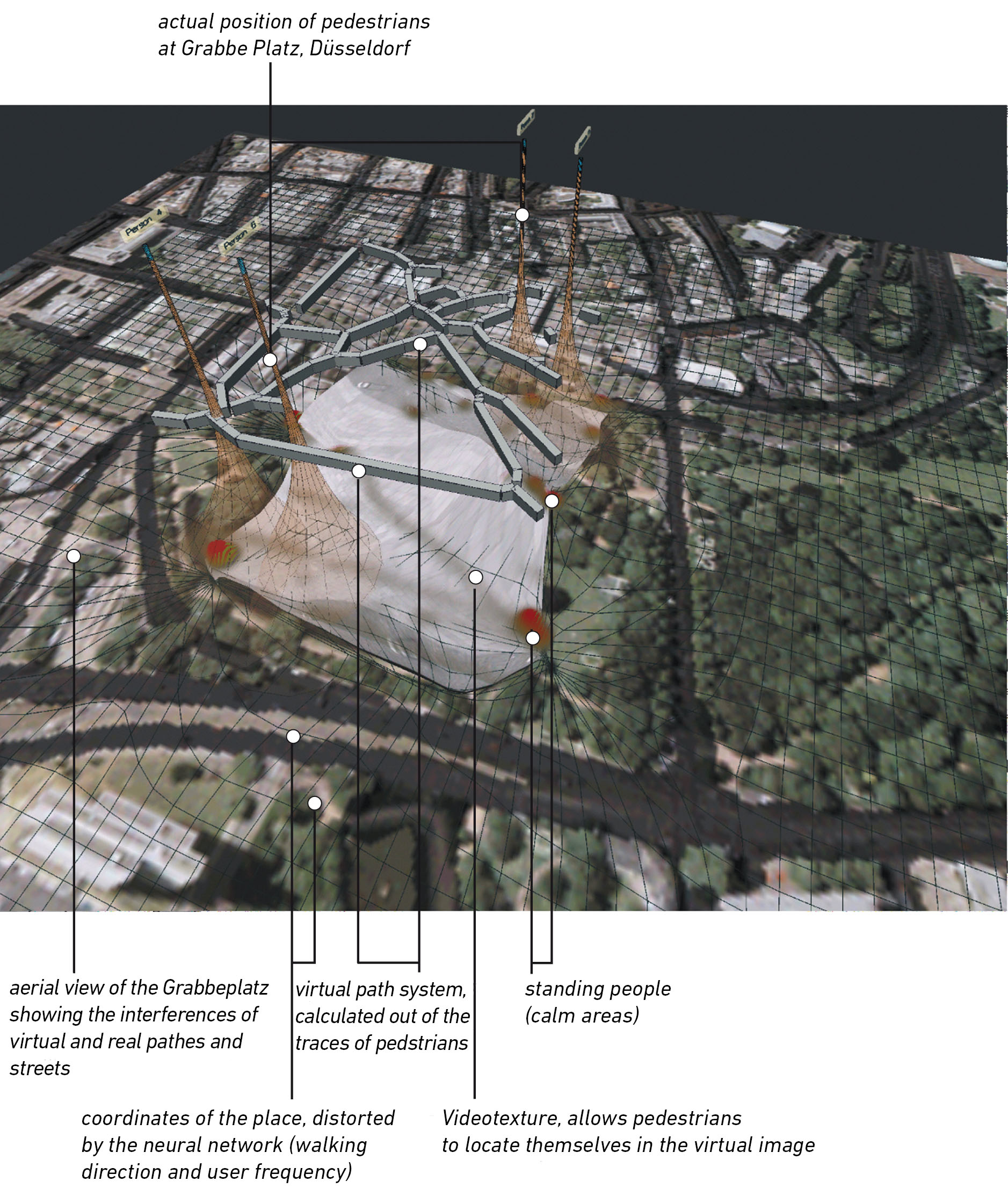
Memory of space is one stage within the framework of the inoutsite project that depicts space in its temporal alterations and explores how individual experiences of „space“ generate the social construct of city. To what extent is the experience of a public space conditioned by me and my (unique) memory – to what degree is it determed by the conventions that result from social intercourse with others and from architectonic/geographic factors? In this case, an large, much-frequented square is monitored by a central camera. The video signals are passed on to two computers which edit the material. The first computer screens an image resulting from an analysis of the movements of people crossing, meeting and/or lingering on the square. Based on the collected movement data of the previous few hours, the second computer calculates an image describing the qualities of the place. The installation „memory of space“ links local and geographical dimensions.
screen print of the software
An aerial view underlying the virtual scene enables an examination of the virtual picture with regard to its potential relationship to large-scale axes. At the base of the virtual picture is a grid-like system of coordinates which, via a self-organizing map (a simple, self-orgaizing neuronal network), is distorted according to the actual usage of the place. At the same time walking speed and direction are applied to the coordinates, pushing them along their direction of travel. A video-texture comprising the video image of the tracked place is mapped onto the coordinate system offering the viewer references to the real place. As a result of this investigation, the monitored place can be divided into „territories“: areas of rest and walking lanes. These lanes are inscribed as a „network of corridors“ (grey lines) onto the distorted (by the movements) reproduction of the square. The remaining spaces – the places where peoples showed a tendancy to dwell (walking speed = 0) – were marked red.
After 1989 a series of drawings of geometric patterns, to be considered as mathematical descriptions of space, evolved out of earlier sculptural works. Space became declined in its proportional rhythms of finite and infinite dimensions and recursions. The pattern drawings which developed are a canon of shapes intended as the foundation for large-scale urban planning.The polymorphism of the patterns enables individual elements to be inserted into already existing proportions, generating a calculated description of the “new” from the already existing “old”. The result of these calculations was a set of basic geometric forms with a long-range effect forming the basis of the first interactive installation “trace pattern”. In this installation patterns are automatically calculated and linked to the movement of people walking in a particular space.The resulting proportions can be examined “virtually”.
For “inoutsite” (see also http://www.inoutsite.de) a tracking-software was developed specifically for the surveillance of public spaces (programm authors:Thomas Kulessa and Matthias Weber). This experience with the machine processing of traces of movement brought about a gradual shift in the main focus of the work – from the construction of descriptive models to the observation of movements. In the installation of the “inoutsite” project the frequency of visits to the site under surveillance was analysed and then translated into image and sound.The resulting virtual three-dimensional shapes can be considered as the first virtual architecture.
Inoutsite I und II zeigen die Statistik der Raumnutzung.
screen print with schematic spacial setting
The red arrrows point in the direction of walking, the lines are the traces of people in the space. The height of the net, which hovers like a virtual roof over the observation area, shows the frequency with which a place is walked.The more people stand at a place, the lower the net sinks. The cloud in the center shows the same information as the net, differentiated by intensity levels. Sounds act as a “monitor” of visitor movement: low tones represent edge positions.
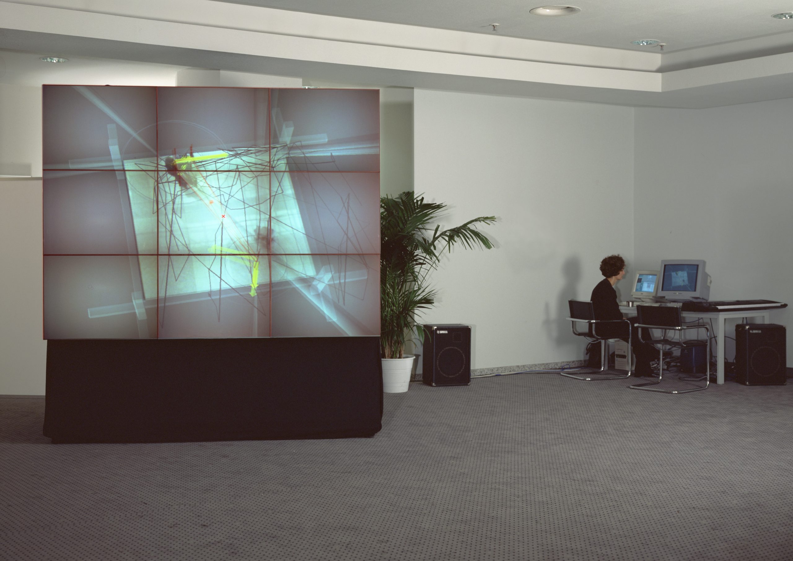
Videoausspielung 1990
Sculpting the clouds (a Text by Katja Davar)
Ursula Damm navigates spaces. As long as I have known her this has been her main occupation in one form or another. I recall her gait at the Art Academy in Düsseldorf that I watched from a distance and even then it struck me that the person coming towards me was somehow navigating the space of that long, endless corridor in a different and definitely less earth-bound way than many. Looking at her artwork over the past years, the spatial aspect has always dominated in some form and her ability to turn what could almost be termed a scientific research project into something visually exciting is for me the core of the work. Assuming that Ursula Damm could just as easily have found her way into pure science, the respect that her work commands is one quite different to the subjectivity often associated with an artistic production. From her sculptural roots that moved into a virtual space, to dynamic architectural arenas and the visualisation of human movement – if one were to analyse the movement through the work as one that is physical, perhaps one could say that the camera perspective (angle) has constantly increased until, as in the most recent works, one has a bird’s eye view of her production. Ursula Damm’s interest in the interior and exterior, i.e. programming and interface, or re/search and re/sult, or even local and global leads me to believe that she is in a strange way attempting to leave a particular state of being in order to discover another. Could this be the age-old desire to fly? To view the world at an angle known only to birds and the wind? Increasingly the works have a real oddness about them, they defy categorisation, which naturally makes them troublesome, as the viewer has to weave an individual vocabulary in order to assess them. Ursula Damm embraces a multi-tiered approach not only through the utilisation of images formed partly through technology, but also through the usage of waste-products – possibly the stuff from which science is made – and lastly her passion for the interactive about which we have argued many a time! The complex reflection on an analogy between space, time, the human and flight all find expression in the work of Ursula Damm, perhaps the question is not when will the clouds be sculpted but from whom.
Im Vorraum ist eine Kamera installiert, welche Besucher aufnimmt. Sie können sich auf einer Videowand sehen, Töne erzeugen und mit den Geometrien spielen, die ihre Bewegungen interpretieren. Pfeile geben die Gehrichtung an, der Durchmesser der Kreise wächst mit der Gehgeschwindigkeit, das hellgrüne Polygon umfaßt Personengruppen, das türkisfarbene Polygon beschreibt den Zwischenraum zwischen zwei Personen, die “Bleistiftlinien” zeichnen die Wege der letzten Minuten.
Trace Pattern Ausspielung
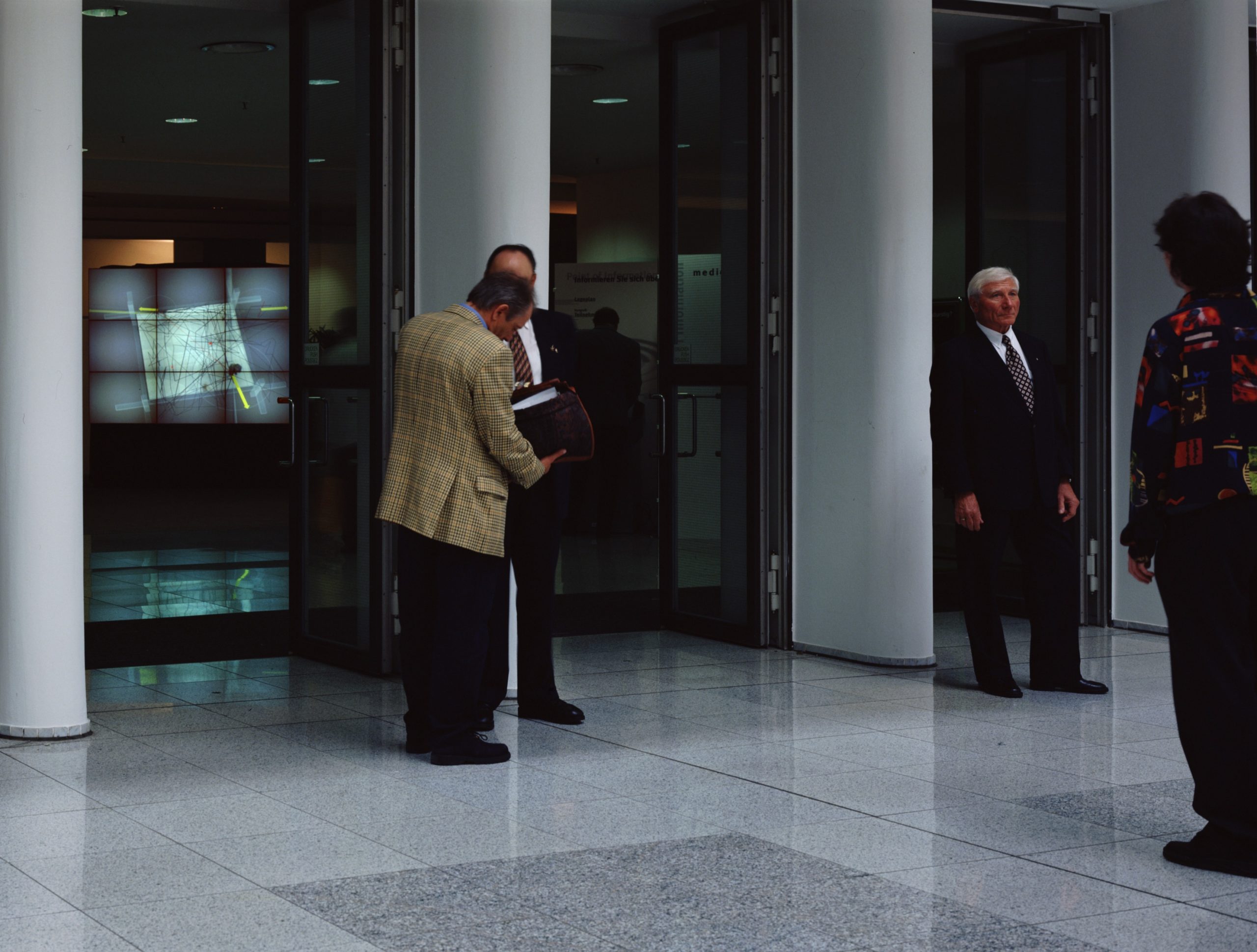
Blick ins Congresszentrum des Multimediaforums in der Messe Köln
lInstallation im Multimedia Forum Köln 1997
Hardware: Tracking System auf Windows Computer, Grafik auf Silicon Graphics
Video von Menschen auf der Kölner Domplatte, erzeugen mit ihren Spuren ein Kurzzeitgedächtnis von Raum (Köln/Mailand 1996)
Blick in des Ausstellungsram von “openSpace” Galerie in Mailand.
Das hier gezeigt Video war eine Echtzeitbewegungsfilterung von einer Aufnahme des Domplatzes in Köln. Die Ausstellung stellte einen Domplatz-Tausch dar, der Blick aus dem Fenster (oben rechts und links von der Leinwand) war fast identisch zu dem Bild im Video.